 We're in beta! If you find a bug or have feedback, let us know in our

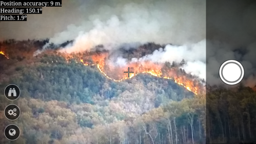
CITISENS - CITIzens as SENSors
Monitor and predict the course of wildfires
- Ongoing
More Information
CITISENS is a novel software service which exploits commodity smartphone sensors and allows citizens to easily georeference a fire-line in real-time and report its coordinates as they are photographing a wildfire. The location/orientation sensors and the camera are used to compute the view-ray of the smartphone, and a digital elevation model is employed to estimate the ray’s intersection with the topography. We have tested the georeferencing accuracy obtained and it is on par with, or even better, than that of existing satellite wildfire hotspot services. When combined with FLogA, a flexible wildfire spread simulator we have also developed, CITISENS offers the following unique advantages: real-time prediction of burn probabilities, dynamic assimilation of citizen-reported hotspots into ongoing simulations for improved predictive accuracy, and decision support to issue citizen alarms based on the estimated time-dependent risk at their location due to an approaching wildfire.
Ticket Required: No
Minimum Age: 13
Languages: English